Archive | American Revolution RSS feed for this section

It’s a fact: Lafayette’s Stop Remembered

30 Jun
Powells Tavern0001 adj watermark

Powell’s Tavern in the 1970’s undergoing restoration.

In 1824, the Marquis de Lafayette was on his way from Richmond to Albemarle County to see is old friend Mr. Thomas Jefferson.

Lafayette’s first stop after leaving Richmond on the River Road (same route you know today) was a lunch stop at Powell’s Tavern located near the eastern line of Goochland (opposite James River Estates). The tavern was first a single clapboard structure constructed about 1770 and still standing. Business prospered and the increase meant expansion for the tavern. A front or second structure was constructed of brick, circa 1820. A narrow passage between the two buildings allowed the carriage to let passengers out under roof – a real first class idea! The distinguished visitor enjoyed a two hour stop over with a “cold collation” served to his party.

At Goochland Courthouse a large crowd awaited his arrival with banners of welcome and a final tribute to the General who saved the young America and gave us freedom and liberty.

There were three levels of public accommodation in those days: ordinaries, taverns, and inns, the latter being the best. The ordinary provided ordinary food for the traveler and waters for horses. Taverns provided food and some bed space. Inns provided food and overnight rooms but one usually shared a room with other tourists. The next tavern up the River Road was George’s Tavern located at the junction of Cartersville Road. The River Road was a winding, steep ups and downs, mud road which followed the river to Scottsville.

(The above is from the “It’s a fact” column that the Goochland County Historical Society contributed to the The Goochland Gazette on October 15, 1987.)

Powell’s Tavern was listed on the National Register of Historic Places in 1973.

Thomas Jefferson’s Elk-hill

31 Jan

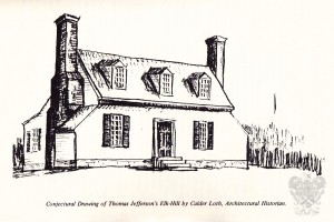
Jefferson's Elk HillIf one is fortunate one sometimes finds a very important place of information while searching for a prosaic bit of evidence in the old deed books in the Goochland Clerk’s Office.

It was finding a deed to a William H. Miller of “Elk-hill” that led to discovering a description of the house owned by Thomas Jefferson in Goochland County called Elk-hill. Prior to this no one seemed to have any idea what the house looked like, what it was built of and how may stories tall it was. All that was positively known was that it was on a high bluff overlooking Byrd Creek near its junction with the Little James, and that it was on the 307 acres which Jefferson purchased from his wife’s sister in 1778. Fortunately, bricks of the foundation and chimneys, as well as huge tree stumps, marked the spot where the house once stood.

The land on which Jefferson’s Elk-hill house was situated was part of a Royal Patent dated June 16, 1714, granting all of Elk Island and 248 acres of upland to Charles Fleming and John Woodson.

John Wayles, the father of Martha Wayles (Skelton) Jefferson, purchased the land in question from Richard Weatherford by deed dated 12 September 1746.

John Wayles married Elizabeth Skelton, widow of Ruben Skelton on October 19, 1748. From this union there were two daughters, Anne and Martha. Anne Wayles later married Henry Skipwith, while her sister Martha, at age 17 married the 22 year old Bathurst Skelton in November of 1766 and moved to Elk-hill. Their only child, John, was an infant when Bathurst Skelton died in 1768. John died in infancy the year his mother, the widow Martha Skelton, married Thomas Jefferson on New Year’s Day 1772 and moved from her father’s home at The Forest, just outside Williamsburg to Monticello. Martha’s father died in May 1773 leaving her a large estate and making Jefferson one of the richest me in Virginia.

On September 21, 1778, during our Revolutionary War, Thomas Jefferson purchased 307 acres of land “with appurtenances” from Henry Skipwith and Anne, his wife, of the County of Cumberland for 710 pounds Virginia money.

The Elk-hill house was certainly built before 1766, when Martha Wayles moved to Elk-hill in November with her first husband, Bathurst Skelton. It may have been built some years earlier by Ruben Skelton whose widow, Elizabeth married John Wayles in 1748.

Jefferson was visited in 1781 at Monticello by Lt. Col. Banastre Tarleton of the British Army under General Cornwallis. Jefferson escaped capture, and Monticello escaped pillage, but Elk-hill was thoroughly worked over by Cornwallis and his troops. In a letter to Dr. Gordon in Paris, dated July 16, 1788 Jefferson states: “Cornwallis encamped his army all along the main James River to a seat of mine called Elk-hill, opposite to Elk Island and at the mouth of Byrd Creek. He remained in this position ten days, his own headquarters being in my house. He destroyed all of my barns, containing all of the same articles of last year, having first taken what corn he wanted, as was to be expected, all of my stock of cattle, sheep and hogs for sustenance of his army and all of the horses capable of service.”

The theft of his property and the burning of his barns in 1781 did not discourage Thomas Jefferson from purchasing on January 21, 1782, a tract of 312 acres from Edward Smith and his wife Sally.  Jefferson also purchased 50 more acres on May 19, 1783 from Judith Smith of Goochland and Ruben Smith of Cumberland County for 50 pounds. This tract adjoined the tract bought the year before by William Holman and William Bowman. The deed has a provision that Judith Smith shall have the right to occupy the house and land during her natural life with free use of water, wood, buildings and enclosures.

Jefferson did not keep his Elk-hill property very long. On August 5, 1799 he sold his 669 acres, all three tracts, to Thomas Augustus Taylor of Chesterfield County. The price was 1500 pounds current money of Virginia.

Thomas Augustus Taylor sold the 669 acre tract almost immediately to Hugh French. Hugh French soon died and his will was recorded on July 3, 1802, naming Robert French and Mason French as executors. By deed dated July 3, 1802, Robert French, acting as executor, sold at public auction the Elk-hill tract for 1701 pounds, 10 shillings to William H. Miller, “reserving one quarter part of an acre for a burying ground, where the said Hugh French is buried.”

William H. Miller took out a fire insurance policy on his dwelling, a kitchen and a barn at Elk-hill on January 28, 1806. This can be seen amongst the records of the Mutual Assurance Company of Virginia at the Virginia State Library. William Miller sold Elk-hill 10 years later to Thomas R. Harrison of Cumberland County who insured his house against fire on June 6, 1815. It is from the descriptions and dimensions given in the two Virginia Mutual Assurance Society policies that Mr. Calder Loth, Historical Architect with the Virginia Historic Landmarks Commission has been able to sketch a “reconstructed” Jefferson’s Elk-hill.

Elie Weeks

The above is exerted from an article written by Elie Weeks in 1971 and was published in the Goochland County Historical Society Magazine issue Vol. 3, No. 1. The article is followed by historical Calder Loth’s “Explanation of the Conjectural Drawing” that explains his drawing of the house. This issue can be purchased in the Society store.

Spring Meeting – 2014

10 May

The Goochland County Historical Society held its first meeting of 2014 on April 27. The setting for the meeting was Byrd Church and author Andrew Jackson O’Shaughnessy was the featured speaker.


Andrew Jackson O'Shaughnessy

Andrew Jackson O’Shaughnessy

A warm clear day brought a large number of Goochlanders out and into the historic church. Society President Wayne Dementi welcomed everyone before introducing Church elder Knight Bowles. Bowles then gave the attendees a brief history of Byrd Church. Vice-President Bruce Venter then took the podium to introduce the speaker, Andrew O’Shaughnessy, the Saunders Director of the Robert H. Smith International Center for Jefferson Studies at Monticello as well as Professor of History at the University of Virginia. Mr. O’Shaughnessy gave a fascinating summary of his book The Men Who Lost America: British Leadership, the American Revolution, and the Fate of the Empire, winner of the 2013 Great Midwest Book Festival in Regional Literature and the New York Historical Society American History Book Prize. During his talk, O’Shaughnessy debunked the myths and stated the real reasons that led the British Empire to the loss of its colonies in the New World. He explained that the loss was not due to a failure of the military or incompetent leadership, though these two reasons have been widely accepted. The loss of America was actually due to a shaky political climate at home and American fighters who would just not give in or give up.


The Men Who Lost America

The Men Who Lost America

Following his talk, Mr. O’Shaughnessy treated all to a question and answer segment and then graciously signed books for those desiring to learn more about this turbulent time period. We would like to extend a special thank you to Louise Thompson, Ginny Olsen and Ginny and Preston Perrin for setting up and taking down the refreshments.

photo2

Goochland – A Historical Sketch

28 Feb

DSCN1382

In the fall of this year, the Goochland County Historical Society will be publishing the 45th volume of our magazine. In commemoration of this, we will be posting a few articles on the blog from the back issues. Our first post will be the first article printed in Volume 1, No. 1, a short history of the county by Helene Barret Agee, the first Society historian.

HISTORICAL SKETCH

Goochland County, named for Sir William Gooch, Lieutenant Governor of Virginia from 1727 to 1749, was formed in 1728 from Henrico, an original shire of the Virginia Colony. The original boundaries of Goochland were from Tuckahoe Creek, on both sides of the James River, west as far as the English King’s Dominion extended. From Virginia were formed the states of Ohio, Kentucky and parts of Tennessee. The present boundaries of Goochland are: Tuckahoe Creek on the east, the James River on the south, Fluvanna County on the west and portions of Louisa and Hanover Counties on the north. The county’s land area consists of 289 square miles. The highest elevation is 520 feet, taken at Shannon Hill, the lowest elevation 110 feet, taken at the point where Tuckahoe Creek joins the James River.

Goochland’s present courthouse is believed to be its third. It was “received” as completed on August 20, 1827, by the Commissioners for the County. The county has had several jails. The last was built of stone and is still standing. The brick wall around the present Courthouse Square was built in 1840.

By virtue of inheritance, Goochland claims Manakintowne, on the south side of the James River where the Huguenots settled in 1700. By the same token the county fell heir to the three original Monacan Indian Village sites namely, Mowhemencho, Massinacak and Rassawek.

Thomas Jefferson was born at Shadwell in Goochland County on April 13, 1743. When Albemarle was formed from Goochland on October 16, 1744, Shadwell then fell within the borders of the new county and Albemarle inherited this historic site. Thomas Jefferson spent his early childhood at Tuckahoe, also in Goochland, where he was tutored by the Reverend William Douglas and others.

George Washington was the first President of the James River Company which later became the James River and Kanawha Company. The James River and Kanawha Canal, on the south border of Goochland, played an important role in the economic and social life of the county. In the year 1808 the canal was considered one of the most successful internal improvements in the country.

Thomas Mann Randolph, born at Tuckahoe, and James Pleasants, born at Contention, served as Governors of Virginia.
James A. Seddon of Sabot Hill was elected to the First Confederate Congress and later became Secretary of War, Confederate States of America.

Goochland furnished a son for the cabinet of each of the opposing governments during the War Between the States, Edward Bates of Belmont in the cabinet of Lincoln, and James A. Seddon in the Confederate cabinet of Jefferson Davis.

Other members of the Bates family in Goochland also became prominent: Frederick Bates was governor of Missouri from 1824 to 1826; James Bates a member of Congress from Arkansas, and Thomas Fleming Bates a member of the Virginia Convention of 1829.

General Nathaniel Massie (born 1763-died 1813) served with the Goochland Militia. Later moving to Kentucky where his father, Nathaniel Massie, Sr., had been granted lands, he established, in 1791, a village which later became Manchester, one of the four earliest settlements in what is now Ohio. He laid off the town of Chillicothe, and became the first Major General of the 2nd Division, Ohio Militia, when Ohio was admitted as a State, serving until 1810. He held many high offices, including the presidency of the Senate.

During the Revolutionary War Lord Cornwallis and is troops invaded Goochland. They encamped at Thomas Jefferson’s estate, Elk-hill, for ten days and destroyed all barns with contents and appropriated all cattle, sheep and hogs for the sustenance of their army, and all horses capable of service. Colonel Tarleton raided Rock Castle (Queen Anne Cottage) and tore from the walls the Tarleton coat-of-arms and carried it away. Upon retiring from the County, Lord Cornwallis admired an imposing view overlooking the James River and declared that if he should ever reside in America this would be his choice for a home site. This location has since been known as Cornwallis’ Point.

On his way to Monticello to visit Thomas Jefferson in 1824, General Lafayette visited Goochland and spent the night at the Courthouse.

During the War Between the States, Colonel Ulric Dahlgren and his troops paid a visit to Goochland, leaving souvenirs at many places, especially Sabot Hill, Dover and Eastwood. Goochland recalls with pride eighteen-year-old James Pleasants who single-handed, “killed one Federal and captured thirteen.”

Those who are interested in Genealogy will be glad to know that Goochland’s official records were not destroyed during “the War”, and that eight counties were formed from Goochland soil since its separation from Henrico on 1, May 1728. These counties are: Albemarle (1744), Cumberland (1749), Amherst (1761), Buckingham (1761), Powhatan (1777), Fluvanna (1777), Nelson (1808), Appomattox (1845). Their early records are available in the Goochland County Clerk’s Office.

Woodlawn

10 Apr

Shielded by a row of trees from an uncomfortably close highway is one of Goochland’s most familiar historic landmarks, Woodlawn. Located at an intersection of Broad Street Road and old Three Chopt Road, the house is just 5 miles west of the Henrico County line. This closeness to a main road helps to make this one of Goochland’s most visible entries on the National Register of Historic Places.

Woodlawn

Woodlawn

Elisha Leake, a Captain in the Revolutionary War, built Woodlawn sometime during the last quarter of the 1700’s. Leake was the owner of two grist mills on Tuckahoe Creek, documented by the mill stones carved into the pine mantel of one of the fireplaces in the home. Elisha Leake died in 1806 and is buried on the property in the Leake family cemetery. His much younger wife, Frances, renounced the provisions of his will and claimed her dower rights, giving her the “Great House” and over two hundred acres of land in the area. She allowed John Trevillian to operate “Trevillian’s Tavern” in the house, which is how it is designated on the Goochland County map of 1820.

Plat of Woodlawn, labeled Greathouse, 1806

Plat of Woodlawn, labeled Greathouse, 1806

In 1834, Colonel Thomas Taylor of Goochland purchased the property known as “Woodlawn Plantation”. Taylor would go on to glory for his part in the Battle of Chapultepec Castle in 1847. Thomas Taylor is said to have placed the United States flag on the Castle, bringing and end to the Mexican-American War. Colonel Taylor’s son, Americus Vespucius Taylor, a veteran of Guy’s Battery of the Confederate Army inherited the house in 1883. Americus left his initials carved into the fireplace bricks and woodwork, testament to his place in the history of the house.

1820 Wood map

1820 Wood map

The house remained in the Taylor family until 1937 when it was sold to Flora Newby Billet who began a total restoration. The 2-½ story Federal house is noted for its hand made bricks, hand sawn beams and four chimneys that conceal pent closets. One of these pent closest conceals a staircase to the second floor. Woodlawn was added to the National Register of Historic Places in 1971 and the house stands today as a private home with a very public history.

Woodlawn

Woodlawn

Contributed by James Richmond of the Goochland County Historical Society

For more information on Woodlawn, read Volume 1, No. 2 of The Goochland County Historical Society’s Magazine. A reproduction of the 1820 map of Goochland by John Wood is available for purchase from the Society. For information on the National Register of Historic Places, visit http://www.nps.gov/nr/

Rock Castle

19 Mar

Named for a high rock bluff that overlooks the James River, Rock Castle was first patented in 1718 by Charles Fleming a Quaker landowner from New Kent County. In the 1730’s, Tarleton Fleming, son of Charles, built the house known today as the Queen Anne Cottage.

Queen Anne Cottage

Queen Anne Cottage

During a visit with the Randolph’s of Tuckahoe, Colonel William Byrd II of Westover Wrote in his journal “A Progress to the Mines” (1732) that Mrs. Fleming (Mary Randolph) was journeying to meet her husband Tarleton at their new home. This would prove to be the first mention of a home on the site. In 1781, as the American Revolution raged on, Lieutenant Colonel Banastre Tarleton visited the house. Tarleton was returning from an unsuccessful attempt to capture Thomas Jefferson at Charlottesville. While raiding the house, he noticed the Tarleton coat of arms above the fireplace. In a fury, he cut down the coat of arms and set fire to the house. The servants put out the fire saving the house from destruction.

The Italiante villa of John Rutherford

The Italianate villa of John Rutherford

Former Virginia Governor, John Rutherford, purchased the house in 1843. Rutherford’s son, John Coles Rutherford enlarged the home, added an Italianate front and laid out the formal garden. General Philip Sheridan raided this house in 1865 in his swing through the area towards the end of the Civil War. The house was again set on fire and once more the servants saved it from burning.

The stairway in the Queen Anne Cottage

The stairway in the Queen Anne Cottage

In 1935, James Osborne purchased the land with the intent of building a new home on the site of the old. He hired noted architect Herbert A. Claiborne III of Claiborne & Taylor to design a new Normandy style home for the site. Claiborne, who had formerly worked on the restorations of Stratford Hall and Wilton, began removing the Italianate façade and found the cottage to be largely intact underneath. The cottage was then dismantled and moved a few hundred feet to its new location. It was at this time that it became known as the Queen Anne Cottage.

Rock Castle 4

The surviving building is a story-and-a-half structure with a clipped gable roof. Inside it has extensive paneling, fireplaces at both ends and a fine staircase that leads to the simpler second floor. The beautiful Queen Anne Cottage survived action in two wars, a remodeling and a move. In 1970, the Rock Castle estate became Goochland’s third addition to the National Register of Historic Places.

Contributed by James Richmond of the Goochland County Historical Society

For more information on Rock Castle (Queen Anne Cottage) read Volume 1.2 of The Goochland County Historical Society’s magazine. For information on the National Register of Historic Places, visit http://www.nps.gov/nr/